
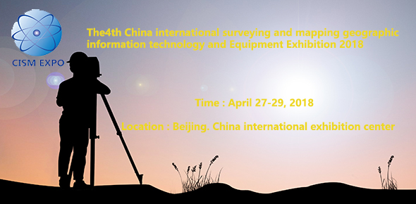
Invitation letter
Organization:
National Surveying and Mapping
Engineering Technology Research Center
China Earthquake Administration
Institute of Disaster Prevention
Disaster prevention and mitigation
emergency Industry Association of China
Overseas cooperation:
GuanHui Exhibition(ShangHai)Co.,Ltd
Supported by:
speed upthe surveying and mapping information system construction to improve the
ability of Surveying and mapping security services.
Exhibition preface:
The cause of Surveying and mapping isan important part of our national economic and social development, the basicguarantee for sustainable development and an important support. At present, thegood trend of new technology for China's rapid economic development and thecontinuous emergence of geographical space, provides a rare opportunity for thedevelopment of China's surveying and mapping industry, is becoming the emergingindustry the rapid rise of the modern service industry and new economic growthpoint; it is widely used in disaster prevention and mitigation, energy
By the national surveying and MappingEngineering Technology Research Center, Institute of Disaster Prevention, ChinaEarthquake Administration, China's disaster prevention and emergency IndustryAssociation, the relevant government departments to vigorously support the"2018 China International surveying and mapping geographic informationtechnology and equipment exhibition" will be held June 27, 2018 - 29 day at
the Beijing International Conference Center was held; this exhibition will be
"speed up the surveying and mapping information system construction to
improve surveying and mapping support service ability" as the theme, to
domestic and foreign related equipment manufacturers of Surveying and mapping
units to promote enterprise brand, expand the market, strengthen exchanges and
cooperation in the surveying and mapping industry at home and abroad, to
improve the overall level of equipment of Surveying and mapping industry, and
make unremitting efforts for the healthy development of the cause of China's surveying
and mapping geographic information. The Organizing Committee of the conference
will be the highest specifications, the most perfect work organization plan for
you to create an excellent supply and demand sides of the exhibition and
exchange platform.
On March 26, 2018 Monday 8:30a.m-5:30p.m
Opening Caremony:
On March 27, 2018 Tuesday 9:00a.m-5:00p.mOn March 28, 2018 Wednesday 8:30a.m-5:00p.m
On March 29, 2018 Thursday 8:30a.m-2:00p.m
Exhibition scope:
1, geographic information enterpriseslarge mapping image and display the results;
2, the surveying and MappingInstruments: total station, level, range finder, theodolite, thermometer, flatinstrument, gyroscope, plotter, swinger, plummet, GPS products, GIS products,handheld GPS products etc.;
3, the mapping software: 3S (GPS, GIS,RS) information system of space data acquisition, processing and processingsoftware, geographic (GIS), management information system (MIS), satellitenavigation and positioning, RS (Yao Gan), cadastral management system,
electronic map system, digital mapping system;
4, peripheral equipment: laserproducts, prism, prism fittings, telescope, bracket, tower ruler, block gridruler, computer peripherals, scanner, plotter, CAD software and equipment,integrated mapping technology and products;
5, the field of communication
technology and equipment and related outdoor activities.
Promotion plan:
CCTV, Beijing TV station, China Daily,xinhuanet.com, Beijing daily, Beijing evening news, people's daily, BeijingYouth Daily, Beijing News, Sohu, the Central People's broadcasting station,science and technology daily, global network, people.com.cn, NetEase, beijing.Invite professional
audience:
During the exhibition will be invited
to surveying and mapping,Remote sensing, detection, monitoring, earthquake,
health, civil affairs, water conservancy, meteorological, land, publicsecurity, armed police, agriculture, forest industry, electricity, education,Construction, safety, informationcenter, search and rescue, frontier defense, sea defense, civil defense air
defense, transportation, Tourism Bureau, aerospace, defense, aviation,
satellite, judicial, customs, army, nuclear industry, industry letter,
environmental protection, maritime, science and technology, marine police,
railway, prison, food, marine, military, medicine, tax, medical, Red Cross,
foundation, postal services, telecommunications, finance, securities, bank,
insurance companyWeapon, ship, colleges and universities, petroleum and
petrochemical, supervision, foreign affairs, Embassy, air traffic control,
airport, port, underground construction, city security, trade, professional
institutions, disaster prevention and other units, as well as Japan, South
Korea, Canada, America, European countries, Taiwan, Hongkong,Surveying and
mapping management institutions in countries and regions such as the United
Nations and related research advisory unit,The most authoritative collection of
military and civilian emergency mechanism, common to create a full range of
Surveying and mapping geographic information exchange meeting.
Standard cost:
1: the standard booth: 9 square meters
(3m * 3M) standard booth, special light (hire since 36 square metre);
2: the domestic unit: RMB 12800 yuan;indoor light: 1280 yuan / square meters; outdoor 1000 yuan / square meters.
3: offshore units: 4000 USD light: 400USD/ square meters;
4: the standard booth includes three
face panels, negotiation table and chair, two spotlights, 220V/5A power supply
socket, carpet and company name lintel board; light does not provide any
exhibition facilities, light management fees and expenses of power supply.
5: the application of conference
sponsorship and attended the speech please call for the relevant data;
Note: exhibitors predetermined standardbooth, if choose double side open booths are subject to 10% double openingbooth fees, the general assembly in accordance with the first sign up, firstarranged in the form of.
2018Chinese international surveying and mapping geographic information technologyand equipment exhibition organizing committee
Contact: Liu Xin
Mobile :0086-(0)132-4080-0242
Tel : 0086-10-8593 4068
Fax : 0086-10-8593 4068
QQ : 861727071
E-Mail : cismexpo2015@163.com
Contact person: Jack Du
Mobile:0086-(0) 13671867442
E-Mail : bj_dxh@163.com
More please visit the exhibition's official website: http://www.cismexpo.com

版权所有:2018中国国际测绘地理信息技术装备展览会组委会
联系人:刘 鑫 13240800242 商务QQ:861727071
电 话:+86-10-85934068 传 真:+86-10-85934068